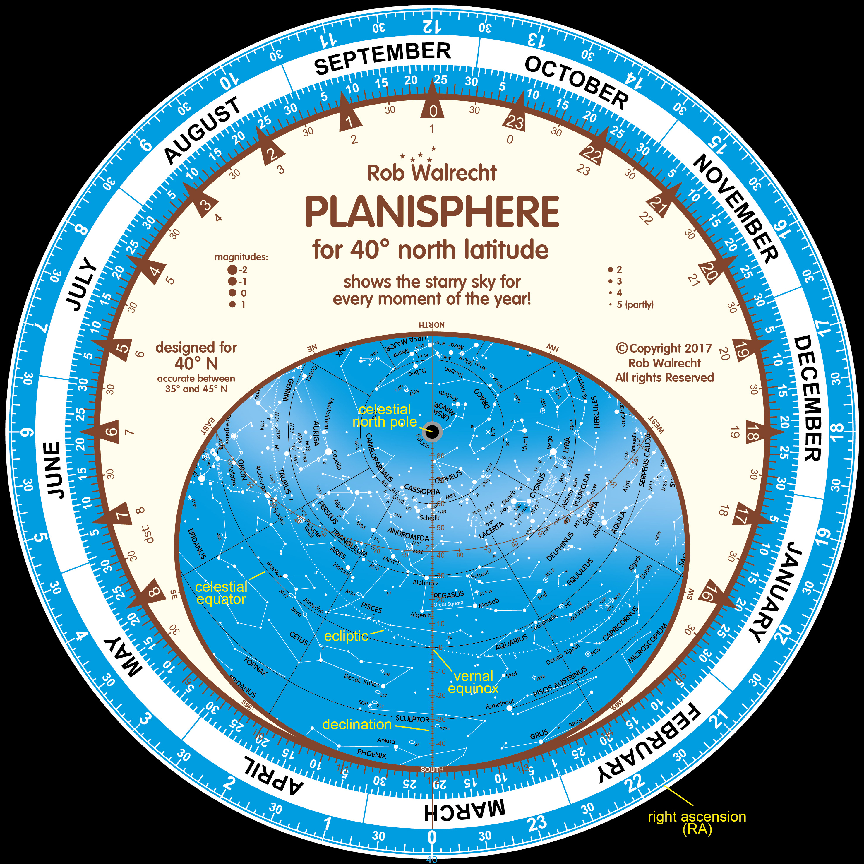
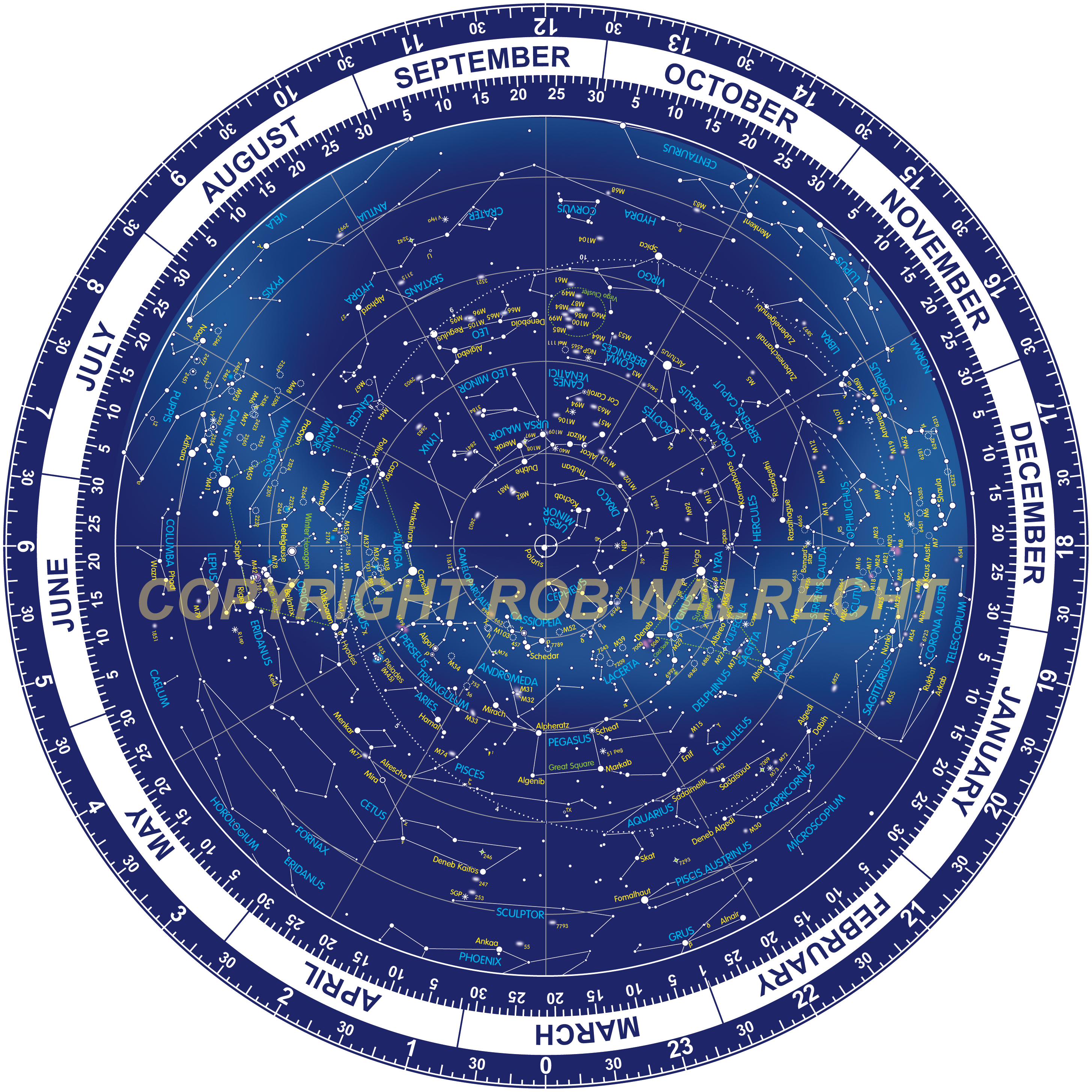
The Planisphere
The Planisphere is your Guide to the Stars. It is the perfect means to learn how to recognise the stars and constellations. Simply set for the date and time, the Planisphere provides a complete overview of all the stars, constellations and deeksky objects that are above the horizon at the set time.
Here is a video showing the possibilities and workings of our Planispheres.
The Planisphere vs apps?
What are the pro's and cons of planispheres and apps? As I don;t use such an app, I cannot say so much, apart from that a Planisphere is certainly more fun and more instructive.
But I found an article,
'Planispheres (Star Maps): Paper or Electronic?', written by someone who is not as biased as I am...
You can see that on this
page.
Now all Messier objects!
In our older two-colour design we already had some 300 'objects for binoculars', like nebulae and galaxies. These included most Messier-objects and many NGC- and other objects.
Since 2016 I have the new full colour designs for all planispheres, to which I had added the M-objects missing in the earlier designs, as well as some other objects that are great to see but were not shown before. Some 16 new objects in total. This new design is perfect for use in the dark with a red flashlight (the earlier design was not good in that respect).
So for skywatchers that love to visit all Messier objects, we recommend our very accurate* and complete planispheres!
Click on the image to see it in high resolution.
 *) I consider myself a student of Wil Tirions, my friend and mentor, who died last July. He taught me how to use Adobe Illustrator for my work, pointed out errors (which he noticed immediately!) and did much more to help me. On my last book presentations, which he never missed, I felt he was proud of me, which was a wonderful feeling!
_-_500.jpg)
Our planisphere for the Netherlands and Belgium
(PLN-NL) was our first in full colour.
Our Planispheres
All planispheres (except the Dutch PLN-NL and the PLN-EQR) are 25 cm (10 inch) in diameter and have instructions and a few tips on the back side. All planispheres are made of high quality sulphate cardboard, protected by a layer of varnish, with an upper disc made of transparent PVC.
The PLN-NL, the standard planisphere for The Netherlands and Belgium, is square (25 x 25 cm/10 by 10 inch) and consists of four pages: one for the star chart, one for the instructions and the other two for a concise introduction to astronomy (see that chapter of this website). That addition makes it the ideal tool for beginners! Unfortunately the round planispheres don't have the space to add this part. The PLN-NL also is the only planisphere that was designed for a longitude other than that of the centre of all time zones: for 5° east (about the longitude of Utrecht, central for the Low Countries). The advantage of this is that it does not have to be adjusted for the time difference between Utrecht and the centre of the MET time zone at 15° east (see 'Concise introduction to astronomy').
The PLN-EQR is an English double planisphere, with a star chart for 10° north and one for 10° south. The direction in which you are looking determines which of the two star charts you would use. The PLN-EQR has the same shape and size as the PLN-NL, although it has two pages taken up by the star charts. One page is used for the instructions, the fourth for an introduction to astronomy.
Design of the star charts
Besides some 700 stars in all 88 constellations, the two ‘mother’ designs (one for the northern and one for the southern sky) from which all planispheres were derived, show some 300 ‘binocular objects’: galaxies, double stars, variable stars, nebulae etc. Apart from these objects a number of special ‘points’ is included, like the centre of our Milky Way galaxy, the galactic and ecliptic poles, the apex (the point towards which the Sun is moving) and the stars Proxima Centauri (the nearest next star!) and Barnard’s star.
The
ecliptic is shown very accurately, including the dates of the Sun’s positions, allowing you to rather precisely determine the times of Sunrise and Sunset (the ‘Tips’ tell you more about this). The planisphere also shows the
celestial coordinates (right ascension - RA - and
declination). The points of intersection of the ecliptic and the
celestial equator (one of the 'declination circles' on the star chart, which are at every 30° of latitude) are the points of the
equinoxes.
.jpg) Left: features like declination, right ascension,
Left: features like declination, right ascension,
the ecliptic and the celestial equator.
Design latitude and longitude
Every planisphere shows the area for which they are perfect, from +5° to -5° of the design latitude. This is a 10° wide band across the entire globe! With this system we have very accurate planispheres for the entire populated part of the world!
For example: the PLN-30 is perfect between 25° and 35° N. This does not mean that it is entirely useless at 37°! But the PLN-40 would be better there. Please consult an atlas to determine which planisphere(s) you need. The time on the planispheres is the normal time for the centre of your time zone, as well as the daylight saving time (smaller). You can easily adjust the planispheres to your
exact location (the other ‘Tip’).
Why this accuracy of +5/-5° of the design latitude? That 5° only influences the lower 5° of the starry sky, or the part of the sky that is just above the horizon. This is a part of the sky that rarely shows much of interest, because of hills, woods, houses and so forth; and if the horizon can be seen, the atmosphere through which you see stars is very "thick", even if the seeing is perfect!
Can a planisphere only be used within the given latitude zone? Not necessarily. If - for instance - a planisphere for 50° north is used on 40° north, than a part of the sky up to 10° above the horizon may be incorrect. In fact there are stars visible in the south that are not shown on the planisphere, while in the north stars rise and set that, according to the planisphere, are circumpolar (so always visible; see "Introduction to Astronomy"). Because most of the time we look at stars and objects higher in the sky, the area just above the horizon is not so important. Unless someone wants to make very accurate use of the planisphere, of course... For those people we have that very accurate system of planispheres that no other planisphere manufacturer in the world offers!
Where to use a planisphere?
|
PLN-60 |
+55° to +65° NB: |
North: North Canada, Iceland. Northern Europe, Northern Russia |
|
PLN-50 |
+45° to +55° NB: |
North: Northern USA, South Canada, Central Europe, Central Asia |
|
PLN-40 |
+35° to +45° NB |
North: Central USA, Southern Europe, Central China, North Japan, Korea |
|
PLN-30 |
+25° to +35° NB |
North: Southern USA, North Africa, Middle East, North India, South China, South Japan |
|
PLN-20 |
+15° to +25° NB |
North: Mexico, Caribbean, Sahara, Saudi Arabia, Central India, Indochina, Taiwan |
|
PLN-S20 |
-15° to -25° ZB |
South: Central South America, Brazil, Southern Africa, Madagascar, Northern Australia |
|
PLN-S30 |
-25° to -35° ZB |
South: Central South America, South Africa, Central Australia |
|
PLN-S40 |
-35° to -45° ZB |
South: Southern South America, Argentina, Southern Australia, New Zealand |
|
PLN-EQR |
+15° to -15° ZB |
Brazil, Northern South America, Central Africa, South India, Ceylon, Indonesia, Southern Indochina |
If necessary, please consult an atlas to determine which of our planispheres you need!
The times shown
All planispheres show the normal as well as the daylight saving time (DST). DST is shown in smaller numbers. Of course, the Sun cannot culminate (be in the south) everywhere in a time zone at the same time (see "Concise introduction to astronomy"). The time we use is always consistent with the solar time along the central
meridian of a time zone, usually a multitude of 15°. On those meridians the Sun is indeed in the south at noon (well, on average... see the Introduction again), but to the east of that meridian the Sun has already gone through the south while to the west it yet has to culminate. This time difference is accurately known, because one day takes 24 hours. We have the Earth into 360 degrees. Divide 24 hours by 360 degrees and you'll arrive at exactly 4 minutes (in time) per degree of longitude!
Example: if you are in Boston, USA, you are at about 71° west. The central meridian of your time zone is at 75° west (Philadelphia). The difference is 4°. That means that the Sun in Boston culminates (and rises and sets) 4 x 4 = 16 minutes before it does in Philadelphia (because Boston is to the east of Philadelphia!). You say therefore that:
- west of the centre: the Sun is 4 minutes per degree ahead of the time used
- east of the centre meridian : the Sun is 4 minutes per degree behind of the time used
The times shown
But what if you're in - say - Los Angeles? That city is in another time zone, with another centre meridian (at 115° west), so the rule is still valid. One difficult time zone is the one that is used in most of Europe - Central European Time (
CET ). It is used from Poland in the east (almost 25° east) to Spain in the west (almost 10° west): an area over 30° wide! Only the UK, Ireland and Portugal (in the west) and some European states in the east are outside the CET-zone.
In each time zone there is always one small area in which time is equal to solar time: near the central meridian of that time zone, which, as we saw before, is usually a
multitude of
15° of longitude. The meridian of Greenwich (0°: the zero meridian) is the central meridian of the area where people use
Greenwich Mean Time (
GMT ). This is also called Universal Time (UT).

_-_1500.jpg)